Tamur River Expedition in Nepal: Trek, White-Water Rafting & Himalayan Adventure
The Tamur River: A Journey Into the Heart of Eastern Nepal
If you’re chasing an adventure that blends multi-day trekking, technical white-water rafting, and raw Himalayan wilderness, the Tamur River Expedition is where it all comes together. I’ve guided adventurers along this eastern Nepal gem for years, and let me tell you—this isn’t just a trip, it’s an immersion.
Originating high in the eastern Himalayas, the Tamur River draws life from glacial melt in the Kanchenjunga region and seasonal monsoon rains. Its sheer remoteness, high volume, and long rafting days make it feel like a true expedition—far from the beaten track, far from the comforts of road access and tourist crowds.
Tamur River Expedition: Fast Facts
- Total Duration: 11 Days (Kathmandu to Kathmandu)
- Rafting Distance: 131 km (82 miles) | ~120 Rapids
- Whitewater Grade: Class IV / IV+ (Continuous Big-Water)
- Trek Duration: 4 Days (Basantapur to Dobhan via Gupha Pokhari)
- Highest Elevation: 2,900 m (Gupha Pokhari)
- Raft Put-in Point: Dobhan / Dovan (730 m)
- Raft Take-out Point: Chatara / Tribeni (100 m)
- Best Seasons: Autumn (October – November) & Spring (April – May)
💡 Ready to Book Eastern Nepal's Premier Wilderness Run?
Join Nepal River Runner for an 11-day fully supported expedition combining the Milke Danda trek with 131 km of Class IV whitewater.
➔ Check Available Expedition Dates & Book Your SeatWhy the Tamur River Is a Rafter’s Dream
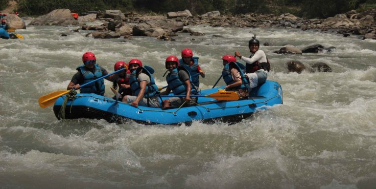
If you’ve ever wondered what it feels like to be in a river that demands every ounce of focus, teamwork, and skill, the Tamur is your answer. With continuous big-volume rapids, dramatic gorges, and forested valleys, every bend brings both adrenaline and awe.
Seasonal fluctuations and upstream hydropower releases make the river dynamic—no two days are ever the same. From Class II–III playful rapids to sustained Class IV and IV+ challenges, the Tamur tests both your paddling and your mental endurance. As a guide, I can tell you: the rush when your raft hits a rapid perfectly—team in sync, water roaring—is indescribable.
Getting There: Kathmandu to Basantapur
The journey begins long before the first rapid. To make the most of the expedition, the team rises before 3:30 a.m., ensuring all logistics are finalized — most of which are pre-checked by the expedition crew the night before. By 4:00 a.m., after a final morning check and meeting with our guests, we depart Kathmandu toward Basantapur. The route follows the BP Highway for around 2–3 hours, reaching a breakfast point at Nepalthok or nearby. After a short rest, we continue for another 4–5 hours, passing Bhiman and joining the Inner Terai Madan Bhandari Highway. Lunch is taken at Katari, Udayapur, or nearby locations. Post-lunch, the journey continues to Dharan, from where we join the Koshi Highway. After roughly 2 hours, we reach Hile, the access point for Puspalal LokMarg, then continue for another 2 hours to arrive at our destination: Basantapur, where we stay overnight in a teahouse.
The next day, our rafting crew departs from Basantapur by bus to the starting point at Dobhan, preparing logistics and coordinating with the trekking crew. Throughout the journey, updates are shared continuously until the rafting and trekking teams converge. Along the way, the route crosses multiple rivers including Roshi, Sunkoshi, and Kamala, passes the historic Sindhuligadhi fortress, and continues across Tamur bridges near Mulghat, offering glimpses of the rivers and hills that define eastern Nepal. On clear days, distant peaks like Kanchenjunga and Makalu hint at the wilderness awaiting us.
Trekking to the Put-In: Days 1–5
The trek to the river is a journey in itself. Following the Basantapur–Gupha–Dovan Sadak trekking route, these days on foot gradually pull us away from roads and routine, drawing us deeper into the landscapes and cultures of eastern Nepal. Over the course of the trek, we pass through traditional villages, rhododendron forests, Himalayan farmland, and high ridgelines. Each morning brings crisp mountain air, and on clear days, distant snow-capped peaks tease the horizon.
When I guide teams here, I often pause at viewpoints—not just to catch our breath, but to let everyone absorb the scale of this region. Eastern Nepal feels vast, quiet, and raw. By the time we reach Dovan (Dobhan), where Mewa Khola joins the Tamur River, there is always a shared sense of anticipation. The river waits below, and with it, the real challenge begins.
Day 2: Trek to Chauki / Mangalbare
Our expedition trekking officially begins from Basantapur. The day starts with a 30–40 minute bus ride, after which we begin walking. From the drop-off point, we climb approximately one hour of stairs to Pathibhara Temple, Sankhuwasabha, locally known as Sano Pathibhara. From Pathibhara, we continue walking for about one hour to Panch Pokhari, where lunch is taken at a small local restaurant. The trail ascends gradually, but the combination of walking and elevation gain makes the day physically demanding. After lunch, we continue trekking toward Chauki, and for those continuing further, another hour’s walk brings us to Mangalbare. By the time we arrive, fatigue sets in—but so does satisfaction. We stay overnight in a local teahouse, where dinner is served and the group settles in for a well-earned rest.
Day 3: Trek to Gupha Pokhari (2,900 m)
After breakfast, we resume trekking toward Gupha Pokhari, a beautiful high-altitude lake situated at 2,900 meters in the Sankhuwasabha district. The trek takes approximately 5 to 6 hours. This section of the trail is especially rewarding. The landscape opens up, cultures shift subtly from village to village, and the forest becomes denser and richer. During the March to June season, the hillsides come alive with multiple varieties of rhododendrons in full bloom, painting the trail in shades of red, pink, and white. On clear days, the views are exceptional. From the trail and around Gupha Pokhari, you can see Mt. Kanchenjunga (8,586 m)—the world’s third-highest mountain—and even Mt. Everest (8,848 m) in the distance. We spend the night camping at Gupha Pokhari, surrounded by forest, silence, and mountain air.
Day 4: Trek to Gorja (1,925 m)
After a hearty breakfast, we descend from Gupha Pokhari toward Gorja, located at 1,925 meters. This day offers a noticeable change in terrain and vegetation. As elevation decreases, the diversity of flora and fauna becomes more apparent. Along the way, we pass through some of the most remote rural settlements in Nepal, places where daily life continues much as it has for generations. The trail gives rare insight into rural mountain living, far from roads and modern infrastructure. We set up camp at Gorja and spend the night there.
Day 5: Final Trek to Dovan (730 m)
The final trekking day takes us from Gorja to Dovan, a descent of several hundred meters that takes approximately 4 to 4.5 hours. As we approach Dovan, the sound of flowing water grows louder, signaling our arrival at the river. Dovan (Dobhan) is the confluence of Mewa Khola and the Tamur River, locally known as Maiwa–Tamur Dovan. Here, we establish our river camp, meet up with the rafting team, and take time to rest and recover from the trek. This is a transition day—trekking behind us, rafting ahead. Boats are prepared, logistics finalized, and the river is assessed. The Tamur waits for us, and the next morning, the paddles will finally touch the water.
White-Water Rafting: Days 5–10
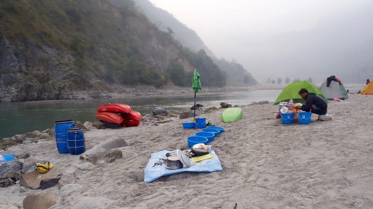
From Dobhan, the six-day rafting portion unfolds over 131 kilometers of river, featuring around 120 rapids. Long, physically demanding days alternate with evenings under Himalayan stars, camping on sandy beaches or beside calm pools.
Day 6: Dovan to Kabeli Khola — The River Takes Control
Four days of trekking are behind us. At Dovan, the expedition finally shifts from boots to boats. We prepare methodically—rafts laid out, safety briefings reinforced. The Tamur allows no casual entries. From the first kilometers, the river asserts itself with authority.
Major rapids arrive in quick succession:
- House Rock (Class IV)
- Pariah Dog (Class IV+)
- Hodson’s Sandwich (Class IV+)
- Hodson’s Last Rite (Class IV+)
These are defining rapids—where teamwork clicks and confidence is forged. Over roughly 25 kilometers, the river pushes hard and rewards precision. We camp beside Kabeli Khola, the river’s sound filling the valley long after darkness settles.
Day 7: Kabeli to Hinwa (Hewa) Khola — Flowing Into Wilderness
The day starts fast. Rapids are immediate and technical until we cross Limbuni Bridge, where the river’s tempo begins to change.
White sandy beaches emerge. The water deepens to a striking blue. Villages become rare. Often, monkeys outnumber people along the banks. Descending toward the Koshi Tappu region, birdlife becomes constant—kingfishers, raptors, and flocks moving overhead. This area alone hosts nearly 500 bird species, and it shows. We camp on a wide sandbank near Hinwa Khola, surrounded by jungle sounds and open sky.
Day 8: Hinwa to Lambu (Dhuwaa) Khola — A Moment to Breathe
The river eases today.
Flat sections allow paddlers to relax and kayakers to explore eddies and side channels. Suspension bridges stretch across the gorge above us, linking villages perched high above the water. A handful of Class II–III rapids keep us attentive, but the focus is enjoyment rather than endurance. We camp beside Lambu Khola and Tamur River confluence, the mood light, energy restored.
Day 9: Lambu Khola to Mulghat — Letting the River Carry Us
After days of intensity, the Tamur offers calm.
We float more than we paddle, passing only a few minor rapids. In about four hours, we reach Mulghat (203 m). It’s a quiet arrival—no adrenaline, just the deep satisfaction of distance covered and challenge met. That night, reflections replace excitement. This is where the expedition settles into memory.
Day 10: Mulghat to Tribeni — The Final Statement
The Tamur saves its closing argument for last.
Paddling toward Tribeni, the river delivers around 30 continuous rapids, tightening its lines and demanding attention until the very end.
The most memorable:
- Ashram (Class IV+)
- Hell Hole (Class IV)
- Bat Below (Class IV)
Once these are behind us, the river widens and Tribeni appears—where the Tamur merges with the converged form of the Arun and Sun Koshi to form the Sapta Koshi. We camp and celebrate the accomplishment of an amazing adventure.
Tribenighat: The Confluence of Adventure
The journey ends at Tribenighat, where the Tamur joins the Arun and Sun Koshi to form the mighty Sapta Koshi River. There’s something almost poetic about it—the rapids ease, the river broadens, and you can finally breathe deeply, reflect, and celebrate.
I tell my teams here: this is where you honor both the river and your own effort. Every challenge, every rapid, every long day on the trail and water culminates in this moment.
Rapid Profile Summary Table
| River Section | Distance | Rapid Grade | Key Rapids & Features |
| Dobhan to Kabeli Khola | 25 km | Class IV / IV+ | House Rock, Pariah Dog, Hodson's Sandwich, Hodson's Last Rite. Non-stop technical paddling. |
| Kabeli to Hinwa Khola | 28 km | Class III+ / IV | Limbuni Bridge, deep jungle gorge, bird watching (Koshi Tappu migration corridor). |
| Hinwa to Lambu Khola | 25 km | Class II+ / III | Wide turquoise recovery pools, surf waves, suspension bridges. |
| Lambu Khola to Mulghat | 22 km | Class II / III | Relaxed river pace, rolling hill scenery, arrival at Mulghat highway bridge (203 m). |
| Mulghat to Tribeni | 30 km | Class IV / IV+ | 30 continuous rapids including Ashram, Hell Hole, and Bat Below. Final Sapta Koshi confluence. |
What We Provide on the Tamur Expedition
At Nepal River Runner, we handle the details so you can focus on the adventure:
- Experienced, licensed rafting guides
- Swift-water rescue and first-aid–trained support
- Rafting equipment, safety kayaks, and support rafts
- Trekking logistics: porters, tents, sleeping gear
- All meals, permits, and expedition coordination
Our goal: keep you safe, supported, and immersed in the true Himalayan experience.
Who Should Join
The Tamur River Expedition is not for the faint-hearted, but perfect for:
- Adventure seekers chasing real Himalayan expeditions
- Rafters eager for sustained, technical white water
- Trekkers comfortable with multi-day hikes and camping
- Nature lovers seeking remote landscapes and authentic cultural encounters
A moderate to good fitness level is essential, but so is a willingness to embrace long days and the unknown.
Final Thoughts: Ride the Waves
I often tell first-timers: the Tamur River isn’t about shortcuts. It’s about progression—step by step, rapid by rapid, discovering both the river and your own limits.
For those ready to commit, the Tamur delivers a rare mix: challenge, beauty, and reward in equal measure. There’s nothing quite like it in Nepal.
Ride the Waves. The Tamur River is calling, with traversing the trails firstly.
For full details and to book, check out Nepal River Runner’s Tamur River Expedition.